
| Home | Butterflies | Dragonflies | Birds (media) | Flora & Fauna (media) | Observations | Species | Mexican Species |
| Download Checklists | Links | My 5 Chickens | Other Photos | The Birding Program | About | GPS | News |
Locality
Kalvebod Fælled
(Denmark)
360
Description:
Natural protected Area (Wildlife refuge).
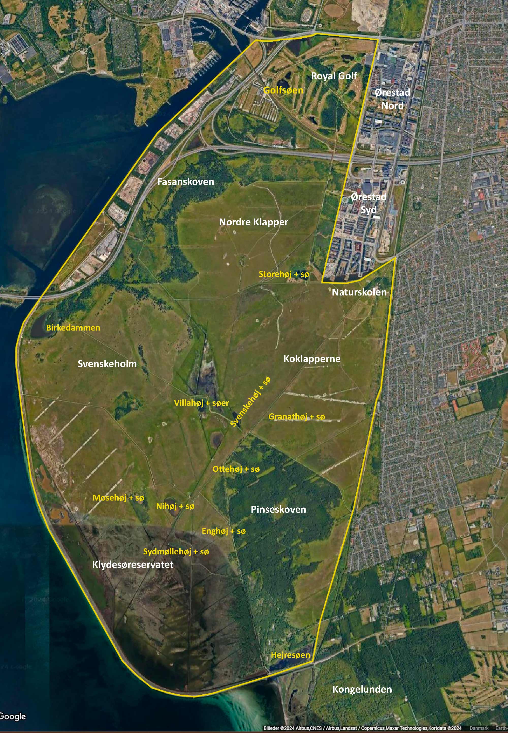
Used to be coastline and shallow waters intermixed with smaller islands. Was reclaimed during World War II when a dike was constructed along the western perimeter. Was a military shooting range for several decades (has been cleaned for defects), but given over to civil recreational use in the mid 80'es. A large part has since then been expropriated in the northeast to be able to build the new neighborhood Ørestad, and the northernmost part is today a golf course (with public access). Size approximately 25 km2. The presentation-map shows the main areas, hills (høj) and lakes (sø).
The area consists of a variety of habitats including shallow lakes, birch forests, open grassland intermixed with large thickets of mainly hawthorn [tjørn] and sea-buckthorn [havtorn]. The forest, Fasanskoven, is found at the northeast corner of the area, along the highway, and the other, and larger forest, Pinseskoven is found in the southeast, occupying almost a quarter of the area. The southwest corner of the reserve, bordering the dike, is a shallow lagoon and adjacent grassing fields working as a bird reserve with no access to the public (but can be overlooked from the perimeter, especially from lookouts on top of the dike). In-between you'll find several short-grassed hills, that used to work as shooting targets when the military was still here. With all the hills there is a corresponding lake.
The area is mainly being maintained with recreational purpose in mind, and is heavily transected by roads and paths. To keep the open areas open, cattle, sheep and horses are grassing throughout the summer. There has been a substantial increased pressure on the area during the last years from more and more city people wanting to get out to explore and use nature.
INTERESTS:
Birds, butterflies, dragonflies and flora and fauna in general. Also very popular with bike-racers, joggers and outdoor enthusiasts taking advantage of the many shelters that have popped up throughout the area. For birdwatching, three observation 'shacks' have been build on top of the dike giving good views of the area. You definitely need to bring a scope to be able to see the birds well, since they are mostly far away (up to a kilometer!)
Dragonflies: The area is excellent for dragonflies, and several of the rarer species show up every year. But it will be too extensive to describe their presence in this note, why you'll have to wait for a detailed presentation, hopefully coming soon.
ACCESS (free 24/7):
Bikes [recommended] or on foot. The area is confined by Vejlands Alle in the north, the dike to the west and south and Ørestad and suburbs of the municipality of Tårnby to the east. Along the perimeter in the north and along the eastern side you'll find many entrances (see map below). Without a car you can take the metro to Vestamager Station, and walk from there, or rent a bike at the nearby Nature Center, Naturskolen. Bus services run south along Kongelundsvej outside the eastern perimeter. Visiting in car, you can park at the main entrance at Otto Buches Alle/Finderupvej (Naturskolen), though this lot is often full. In the south you can park at Ugandalågen, Hilversumlågen or at Frieslandslågen, or if you intend to visit the western area around Birkedammen, where the highway-bridge crosses to Avedøre (Sjælland), you can decide to park on the other side of the bridge, at Avedøre Holme, and access crossing the bridge on foot or bike, or you can park at Selinelågen, marked on the map, or further along at the end of Selinevej and walk from there (you'll have to climb a 15 meter tall dike). Whatever you do, understand that the distances at this locality are large, and it is often windy and there might be a bit of a way to finde shelter from the elements when needed. But otherwise it is lovely!


